

Biking, ATVing and Auto Touring
Innumerable biking opportunities are found near Likely Place, beginning with our own hiking/biking trail and extending through the thousands of miles of roads and trails in the Modoc National Forest and South Warner Wilderness. The following maps guide you to some of the most convenient rides, but dedicated bikers will discover many more. You can also drive most of these routes.
WILDLIFE: Modoc County is sparsely populated by humans, but rich in wildlife. Besides the millions of waterfowl and raptors that stop here on their annual migrations, Modoc County is home to antelope, Rocky Mountain elk, mule deer, coyotes, mountain lions, black bears, bobcats, Bighorn sheep, wild horses, and many smaller mammals. You are unlikely to see all of these creatures... but you will see some of them.
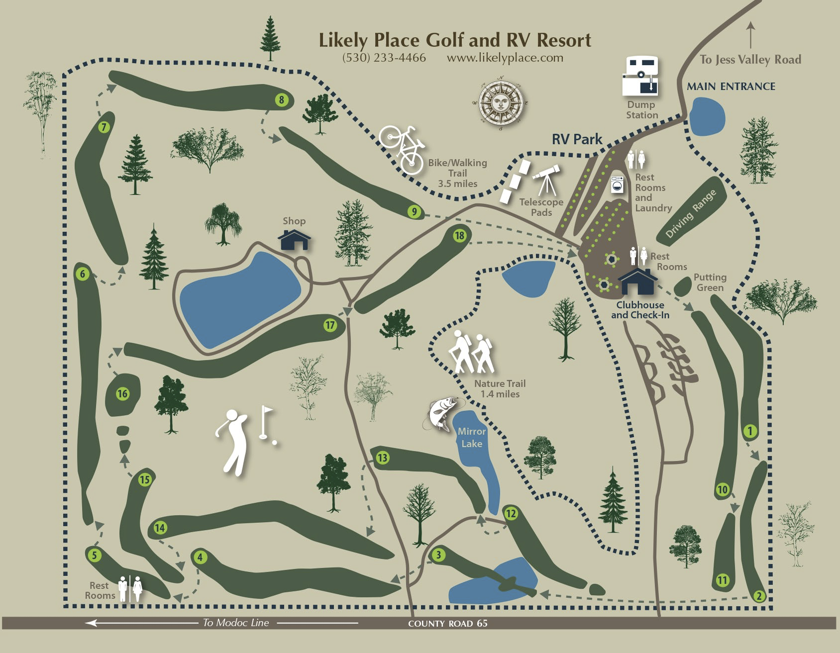
On-Site At Likely Place
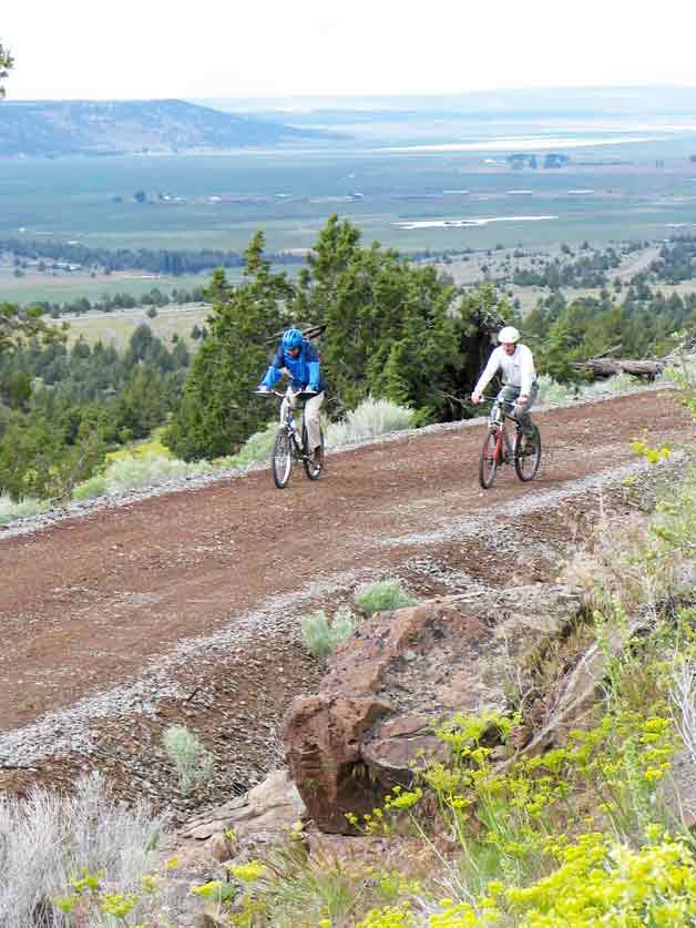
Perimeter Hiking/Biking Trail
The most convenient mountain bike ride around Likely Place is our dirt/gravel 3.5 mile biking/hiking trail which encircles the 520 acre park. The rider will probably see wildlife, enjoy views of the golf course and nearby ranches, and gaze at the 10,000 foot peaks of the high Warner Mountains to the northeast, covered with snow in the Spring.
Please stay on the trail and remember – hikers have right-of-way over bikers. ATV's may enter and exit the park but are not to be used on trails inside the park.
Nearby Opportunities
Likely Place to Likely
3 miles each way. For a pleasant ride on a paved road, and a dose of local culture, exit Likely Place to the North via the main road and turn left (West) on Jess Valley Road toward Likely (pop. 79).
The few places to stop in Likely are quaintly colorful and one, the Likely General Store, should not be missed. It comes complete with gas pump and ice machine out front, wooden floors, 1940's décor, and two levels of most everything you ever imagined you'd need – or maybe didn't. Overalls, cast iron skillets, painted cow skulls, you name it. Be sure to tour the downstairs and enjoy the odd collections.

Complete with gas pump and ice machine

A small part of the basement
Then there's the "Likely Saloon", a watering hole which proudly advertises "Spirits to Go" and is a good spot for cold refreshments. The décor is unusual, but slide up to the bar and enjoy making the acquaintance of Tom, the proprietor

And at the north end of town is a tiny crafts and quilt shop, "Rose's Quilts", run by a lovely lady who personally hand makes each and every quilt in her shop.
Return the way you came, or turn south and ride the gravel "Indian Road", entering Likely Place at our South gate.

Likely Place to the town of Likely
Further...
Likely Place to Mill Creek Falls
The 26.6 mi. round trip from Likely Place to Mill Creek Falls and Clear Lake is a paved-all-the-way road trip, but it does have its ups and downs.
Exit Likely Place to the North, turn right (East) on Jess Valley Road and track the South Fork of the Pit River descending from the South Warner Wilderness Area, fed by melting snow. This road runs through a volcanic canyon with extensive lava rock cliffs on the north side and the river on the south.
Leaving the canyon you emerge into some of the most beautiful and productive ranch land in Modoc County, the Jess Valley.

This highway ride climbs from 4,200' at Likely Place to the 4,800' elevation of Mill Creek Falls, with several climbs and descents enroute
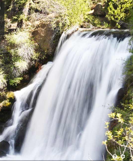
Mill Creek Falls
The ride ends at the Mill Creek Campground where you can hike about ¼ mile to the overlook of the falls and, backtracking a short ways, on to scenic Clear Lake which is stocked with trout and is good fishing

Clear Lake Near Mill Creek Falls

Likely Place to Mill Creek Falls and Clear Lake
(if you don't care to bike this route, it is an enjoyable drive)
Further Yet!
Likely Place to Blue Lake
This 17.4 miles each way road trip to Blue Lake Campground is a bit of a climb. Blue Lake, a sparkling 160 acre jewel set in a valley, is known for fine fishing and boating as well as its cool, relaxing environment.

Blue Lake Boat Dock
Exit Likely Place to the North, turn East on Jess Valley Road to its intersection with the Blue Lake Road, turn right (South) and continue on to Blue Lake

Likely Place to Blue Lake
Closer...
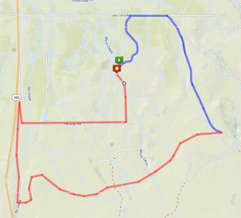
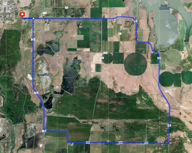
Likely Place to West Valley Reservoir
A shorter road ride takes the biker from Likely Place to West Valley Reservoir, a popular fishing lake whose water irrigates crops and fields in this area. Late in the summer the water level may be drawn down, so this trip is better in the Spring and early Summer. Mud Lake, depicted on the map as water, is usually dry so ignore it.

West Valley Reservoir
Leave Likely Place via the north main gate, turn right on Jess Valley Road to its intersection with West Valley Road, turn right and stay on gravel West Valley Road til you reach the reservoir. There are no services. This ride is 6.4 miles each way

Likely Place to West Valley Reservoir
More Mixed Surfaces
Modoc Line
The following rides are over both paved and gravel surfaces. Only the shortest ride, Likely Place to Hairpin Curve on the Modoc Line, is suitable for the casual biker. The Likely Place to Madeline and mid-elevation South Warner routes are for riders in good physical condition.
The Modoc Line, an abandoned narrow gauge railroad line owned and maintained by the Lassen Land & Trails Trust (www.lassenlandandtrailstrust.org), is open to the public. It runs south 89 miles from near Alturas, passing through Likely, ending near Honey Lake. It is suitable for hikers, bikers, ATVs, and other 4WD vehicles such as Jeeps or Suburbans.
The rails have been pulled and the roadbed graded over these routes. The Line traverses remote public and private lands with no place to obtain supplies so carry all you expect to need and have a backup plan in case of breakdown.
Likely Place to Hairpin Curve
The easiest ride on the Modoc Line, 11 miles round trip, runs through one of the most scenic parts, the Hairpin Curve over Sage Hen Summit.
Trains climb hills poorly and are generally limited to grades of 3% or less. When a steep hill was encountered, railroad builders made long sweeping curves along contour lines so trains could climb gradually. Sage Hen Summit is such a curve, doubling back on itself like a giant, miles-long hairpin.
Even so, Modoc Line trains still needed extra engines and the town of Likely enjoyed prosperity staging rail crews and equipment to boost heavily-loaded Oregon lumber trains over Sage Hen Summit toward Reno and the East.
Depart Likely Place to the North, turn East on Jess Valley Road, then South on West Valley Road to where the rail line and road nearly converge. Here the rider can join the rail line, choosing to continue further southerly on the roadbed or turn northerly and enjoy the scenic downhill return to Likely Place. A southerly turn gives the rider a grand view of Hairpin Curve and the valley lands below before returning to the north and Likely.

Bikers descending Hairpin Curve
Suitable for hikers, bikers, ATVs and 4WDs, this route runs through cattle ranches with several gates which should always be closed after you pass as you may encounter cattle or horses. Although the Modoc Line right-of-way is owned by Lassen Land & Trails Trust, the Trust cooperates with local landowners to help control their herds by allowing ranch gates
Likely Place to Hairpin Curve on Modoc Line
45 Mile Round Trip
Likely Place to Madeline, Return via Modoc Line
This day long loop trip is one of the most scenic rides. The outgoing southerly stretch passes east of 7100' Tule Mountain via Forest Service roads to Madeline and the northerly return follows the Modoc Line passing west of Tule Mountain.
Except for the few miles next to Highway 395 north of Madeline, this is remote but very beautiful country. Spring with its wildflowers and Fall with its milder weather are the best times to travel this route. Summer riders should start early.
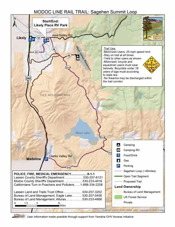
Exit Likely Place to the North, turn East on Jess Valley Road then South on West Valley Road. About ¼ mile south of the West Valley Fire Station, depart West Valley Road to the right and proceed south on rough, dirt and gravel Forest Service Road 2313. Spring flowers here are abundant and colorful. Continue south, perhaps stopping at Moon Lake, to the Blue Lake/Clarks Valley Road, then west to Madeline
Bikers on the Modoc Line
At Madeline join the Modoc Line and proceed north over Sage Hen Summit and Hairpin Curve to Likely, then go east via the Indian Road to the Likely Place South gate or take Jess Valley Road to the North main gate.
This route can be traveled by bikes, ATVs, or 4WD vehicles such as Jeeps or Suburbans. Take everything you may need, there are no services or supplies. Make sure someone will look for you in the event of a breakdown
64 Mile Round Trip
Through Warner Mountains, Modoc NWR and Alturas Farms
This is a terrific route for an all-day trip whether on bikes or an auto tour. Most of the route is pavement albeit of a mixed quality. However 15 miles or so of West Warner Road is good quality gravel which eliminates the use of racing bikes.
Exiting Likely Place turn east on Jess Valley Road alongside the Pit River, then travel north on West Warner Road for a mid-elevation ride along the west side of the Warner Mountains through beautifully forested lands. Take your time, there are many interesting side roads to explore

West Warner Road, gravel for 15+/- miles
Turning northwest you drop into the Pit River Valley, skirting the north side of Dorris Reservoir, and proceed south and west through the Modoc National Wildlife Refuge. Here, in season, you may see many thousands of waterfowl while out of season you may see antelope and other wildlife

Pit River Valley, Modoc NWR & Dorris Reservoir in background
Crossing Highway 395 your route turns south on flat valley roads through giant Alturas Farms, one of the largest producers of wild rice in the world. Antelope often are seen grazing here

64 miles – West Warner Rd, Modoc NWR, Alturas Farms
Continuing south you eventually reach Likely and turn east on Jess Valley Road to return to Likely Place. Total 64 miles, 2+ hours by car
Wildlife Viewing By Bicycle
Modoc National Wildlife Refuge
The Modoc National Wildlife Refuge in Fall and early Spring is a bird watcher's delight.
The flat, wet valleys between Alturas and Klamath Falls are the staging area for millions of migratory waterfowl on their Fall southerly migration and north again in the Spring. Ducks, geese, swans, cranes, and myriads of shorebirds, along with predators such as eagles and hawks, gather in the vast marshes of the Pit and Klamath River Valleys. Beginning in early Fall, remaining until frozen out by ice, then returning as the waters thaw, they are just a glimpse of the vast bird numbers the Pacific Flyway once hosted. Besides waterfowl you may see Pronghorn Antelope as they also live in the Pit River Valley.
The Modoc National Wildlife Refuge is ideal for a pleasant auto or bicycle trip observing wildlife. Nearly level, this is easy peddling on paved roads.
Begin in Alturas on E McDowell Ave which becomes Parker Creek Road. Go east on Parker Creek Rd and turn south on Co Rd 115. Proceed south to Co Rd 59B (Pine Creek) and turn left (east) remaining on that road til it dead ends into Co Rd 57. Turn left (north) and stay on Rd 57 until it rejoins Co Rd 56 (Parker Creek Rd), then west to your starting point.
Go by the Refuge Headquarters to pick up printed information and visit with one of the Ranger/Naturalists who can direct you to the best viewing. During waterfowl season hunting is allowed on parts of the refuge. Bring binoculars. If the weather's crummy, drive the route. Waterfowl love bad weather.
Topo of Modoc National Wildlife Refuge Ride/Drive
If you would like a guided tour of the Modoc NWR by one of the ranger/naturalists, inquire at the check-in desk. With sufficient notice and a minimum group of 10, we can ask the rangers to give you a personal tour
ATVing & AUTO TOURING
In The South Warner Wilderness Area And Modoc National Forest
Likely Place is the spot for ATV enthusiasts. You can depart on a mountainous adventure right from our RV park and head to the Modoc Line. This 85-mile rail trail runs from Wendel Road in eastern Lassen County to Likely in southern Modoc County. An abandoned narrow gauge rail line owned and maintained by the Lassen Land & Trails Trust, this is an off-road experience unlike any other.
The trail traverses over 2,000 acres of some of northeastern California's most dramatic rangeland with views of the Warner mountain ranges and opportunities to see wildlife, including herds of pronghorn antelope, dozens of bird species, and many other critters calling the area home. The trail corridor connects BLM lands from Biscar Reservoir to the Tule Mountain Wildlife Study Area.
Rides departing Likely Place on the Modoc Line range in length and experience levels, but accommodate all types of off-road vehicles. With many remote areas, the Spring and Fall tend to be the best times to travel these routes. The adventures include:
- Likely Place to Hairpin Curve. One of the easiest rides, this 11-mile excursion runs through one of the most scenic parts of the entire trail system.
- Likely Place to Madeline, return via Modoc Line. This outgoing southerly stretch passes by Tule Mountain and Madeline for 45 miles of riding fun.
- Likely Place to Warner Mountains, Modoc NWR, and Alturas Farms: A 64-mile outing, riders will cross through forest lands, a wildlife refuge, and farmland boasting the largest production of wild rice in the world.
The Modoc National Forest covers 1.65 million acres starting with the 10,000' Warner Mountains on the east (considered by geologists to be a "spur" of the Cascades) and extending west and northwest to include the Lava Beds National Monument in the northwest. About 3,000 miles of roads and trails lie within the forest.
The South Warner Wilderness Area, a 70,000 acre portion of the Modoc NF, lies at the southerly edge of the Warner Mountains, close to and readily accessible from Likely Place via Jess Valley Road. It contains 79 miles of maintained trails, another 20 miles of unmaintained pathways, plus many roads.

Forest Service maps of roads and trails within the South Warner Wilderness and in the Modoc NF can be obtained from the US Forest Service on West 12th Street in Alturas. Copies are in the clubhouse.
The Forest Service has specific policies regarding hiking, biking, and ATVing within the forest and users should consult the USFS website for the Modoc NF (www.fs.usda.gov/modoc/) before risking a violation. PDF's of road and trail maps are also available on this site, but the scale makes them difficult to use.
Do You Have A Favorite Route?
Have you discovered a route you like in this area? Tell us about it, make a map, take some photos and email it to us ( info@likelyplace.com ). We'll add it to the site and give you credit.
WARNING: While most rides listed here are on-road, this is a rural area, roads are lightly traveled, and "road trip" does not always mean smooth paved surface. Racing bikes with thin, easily punctured tires are NOT RECOMMENDED. Mountain or "gravel" bikes with heavier tires are best. There are no services on most routes. Be sure someone who knows where you are going will search if you fail to return on-time. Do not rely on your cell phone for a rescue. Carry all supplies you will need. Err on the side of caution.